- Aberdeen Oil Works
- Addiewell Oil Works
- Almondhill Oil Works
- Annick Lodge Oil Works
- Arden Oil Works
- Armadale Oil Works
- Auchenheath Oil Works
- Avonhead Oil Works
- Balgray Oil Works
- Ballat Oil Works
- Bathgate Oil Works
- Bathville Oil Works
- Bellsdyke Oil Works
- Bellsquarry Oil Works
- Benhar Oil Works
- Binnend Oil Works
- Birkenshaw Oil Works
- Bishop Street Oil Works
- Blackburn Oil Works
- Blackstone Oil Works
- Blackstoun Oil Works
- Blochairn Oil Works
- Boghall Oil Works
- Bredisholm Oil Works
- Breich Oil Works
- British Asphalte Oil Works
- Broxburn Oil Works
- Broxburn - Bell's Stewartfield Oil Works
- Broxburn - Albyn Oil Works
- Broxburn - East Mains Oil Works
- Broxburn - Greendykes Oil Works
- Broxburn - Hallfarm Oil Works
- Broxburn - Hutchinson's Oil Works
- Broxburn - Poynter's Oil Works
- Broxburn - Steele's Oil Works
- Broxburn - Steele's Stewartfield Oil Works
- Buckside Oil Works
- Burngrange Oil Works
- Calderbank Oil Works
- Canalbank Oil Works
- Champfleurie Oil Works
- Clippens Oil Works
- Cobbinshaw North Oil Works
- Cobbinshaw South Oil Works
- Coneypark Oil Works
- Craigie Oil Works
- Crown Point Oil Works
- Dalmeny Oil Works
- Deans Oil Works
- Doura Oil Works
- Drumbow Oil Works
- Drumcross Oil Works
- Drumgray Oil Works
- Dryflat Oil Works
- East Fulton Oil Works
- East Hermand Oil Works
- Eldin Oil Works
- Falkirk Oil Works
- Fergushill Oil Works
- Forthbank Oil Works
- Forth & Clyde Oil Works
- Gavieside Oil Works
- Grange Oil Works
- Grangepans Oil Works
- Greengairs Oil Works
- Hareshaw Oil Works
- Hartwood Oil Works
- Hawick Oil Works
- Hermand Oil Works (1866)
- Hermand Oil Works (1883)
- Holmes Oil Works
- Hopetoun Oil Works
- Hurlford Oil Works
- Inkerman Oil Works
- Inverkeithing Oil Works
- Kilrenny Oil Works
- Kilwinning Oil Works
- Kirkmuirhill Oil Works
- Kirkwood Oil Works
- Lanark Oil Works
- Lanemark Oil Works
- Levenseat Oil Works
- Limerigg Oil Works
- Linwood Oil Works
- Loanhead Oil Works
- Lochburn Road Oil Works
- Lochgelly Oil Works
- Longrigg Oil Works
- Magdalene Oil Works
- Methil Oil Works
- Millburn Oil Works
- Nettlehole Oil Works
- Niddry Castle Oil Works
- Nitshill Oil Works
- Oakbank Oil Works
- Palacecraig Oil Works
- Pathhead Oil Works
- Patterton Oil Works
- Pentland Oil Works
- Philpstoun Oil Works
- Port Dundas Oil Works
- Possil Oil Works
- Pumpherston Oil Works
- Raebog Oil Works
- Riggend Oil Works
- Rochsoles Oil Works
- Rochsolloch Oil Works
- Roman Camp - Almondfield Oil Works
- Roman Camp - Cawburn Oil Works
- Roman Camp Oil Works (1892)
- Roman Camp - Shale Oil Works
- Rosebank Oil Works
- Roughcraig Oil Works
- Rumford Street Oil Works
- Seafield Oil Works
- Shawsburn Oil Works
- Sheepford Locks Oil Works
- Shettleston Oil Works
- Shotts Oil Works
- Stand Oil Works
- Stanrigg Oil Works
- Stonehouse Oil Works
- Straiton Oil Works
- St. Rollox Works
- Swinehill Oil Works
- Tarbrax Oil Works
- Uphall Oil Works
- Uphall - Railway Oil Works
- Uphall - Wyllie's Oil Works
- Vulcan Chemical Works
- Wardend Oil Works
- Wattston Oil Works
- Westfield & Capeldrae Oil Works
- Westwood Oil Works (1941)
- Westwood Oil Works (1866)
- Whitebog Oil Works
- Whitehill Oil Works (Lanarkshire)
- Whitehill Oil Works (Midlothian)
- Whiterigg Oil Works
- Woodhall Oil Works
Stonehouse Oil Works

Not listed by Redwood.
In his publication "Damn few an' they're a' died" (c. 2000); local historian John Young identifies the location of the oil works as "across from a bend in the River Avon known locally as "The Ritchies"." An inscription on the rear of a local postcard provides evidence for this. John also quotes a Geological Survey publication, referring to a location "between the viaduct and the Meetings, adjacent to Double Dykes but on the other side of the river" (i.e. in the vicinity of 55.709408, -3.969672) notes " the Musselband is also well exposed in the Avon Water, where the shales associated with it were mined on a small scale for their oil content".
Notes to British Geological Survey, Geological map - sheet No.22 (1872) makes reference (as a fossil site) to "Oil shale works, Avon water, 1/2 mile above its junction with Cander Water about 1 ¼ miles N, by E. of Stonehouse."
The 1871 census lists nine individuals with oil-related employment in Stonehouse. These include William Stewart, described as "Superintendent of Shale Works."
On the north side of the River Avon, a roadway can be traced from Millheugh Brae (55.706062, -3.983364), beneath the piers of the former Avon Viaduct to the sites of two drift mines - Kittymuir No.1 and Kittymuir No.2 - coal workings dating from the 1920's or 30's. Waste from these two mines is still apparent, but nothing in the way of brick debris or burnt shale that might indicate the site of an oil works.
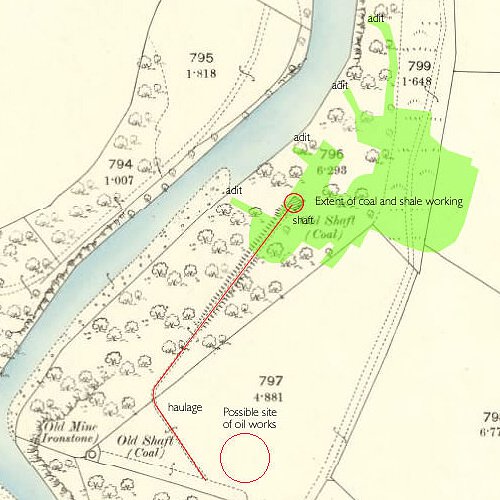
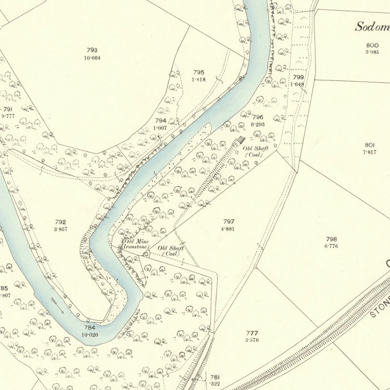
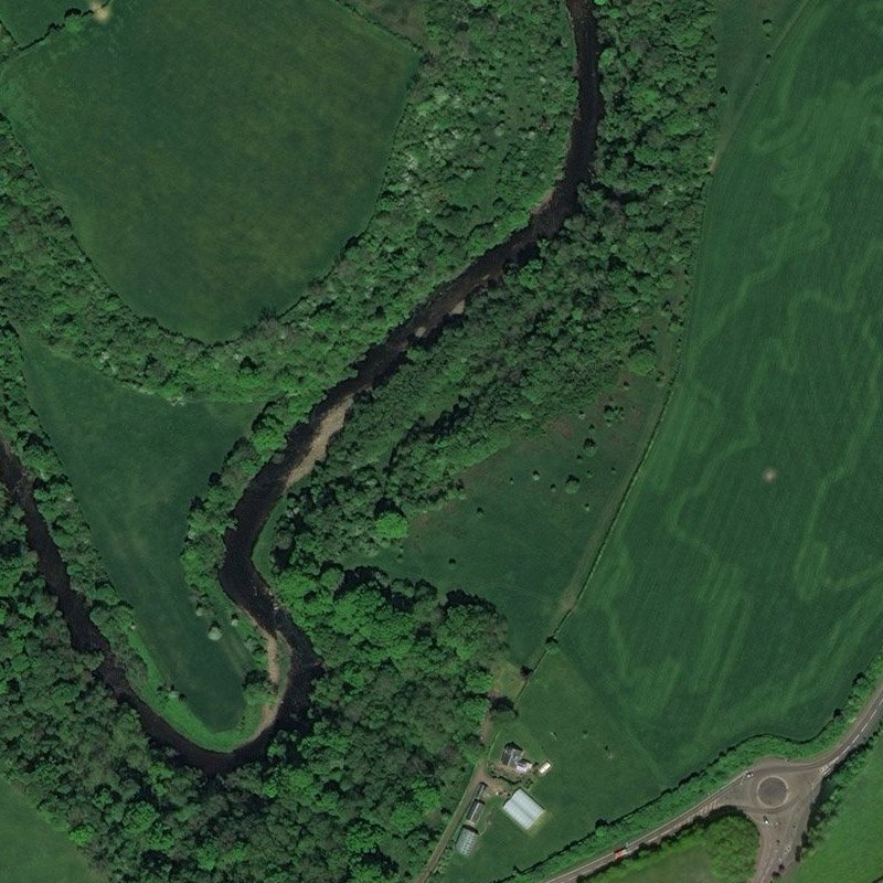
British Geological Survey mine abandonment plan LSP1482 is a rough pencil sketch on tracing paper that shows an area of shale and coal workings on the south side of the River Avon. Four adits spaced about 100 feet apart are shown, extending about 500ft into the river bank. The plan notes the thickness of seams; ("Shale 17", Iron 6", Coal 6"). When this mine sketch is superimposed on the second edition OS map (c.1896) it is apparent that an "old shaft" marked on the map (55.705776, -3.971800) would pierce these workings. The map suggests that this old shaft, sited on the slope of the river valley, was linked by an inclined road or haulage to level ground in the vicinity of the present Townlands Farm. Part of the route of the haulage can still be seen as a crop mark on aerial photographs.
Available evidence suggests that the most logical and likely site of the oil works would be in the vicinity of Townlands Farm. This site would be easily accessible from Stonehouse by a roadway leading to Cochrane street in Stonehouse and crossing the railway by an overbridge.
John Young has also provided the image of an egg-ended boiler which survives in the river near "Millers Brig", and is thought locally to have come from the oil works. The authors of this website have yet to locate this boiler, but did photograph a length of riveted wrought iron pipe, or vessel, on the south bank of the river about 120m downstream of Miller's Brig (55.709079, -3.969395). Many fragments of bituminous shale occur in the river at that point.
Mapped by the Ordnance Survey of c.1898, annotated to show the extent of shale workings.
| Date | Rateable Value | Owner | Occupier | Notes |
|---|---|---|---|---|
| 1870 | £100 | McNaughton & Aitken | McNaughton & Aitken | |
| 1871 | £100 | McNaughton & Aitken | McNaughton & Aitken | |
| 1872 | £50 | McNaughton & Aitken | McNaughton & Aitken | |
| 1873 | £50 | McNaughton & Aitken | McNaughton & Aitken | Not working |
| NO FURTHER ENTRIES |
Recent images

Likely site of Stonehouse Oil Works, a platform of flat land adjacent to Townlands farm. Looking north east. July 2014.

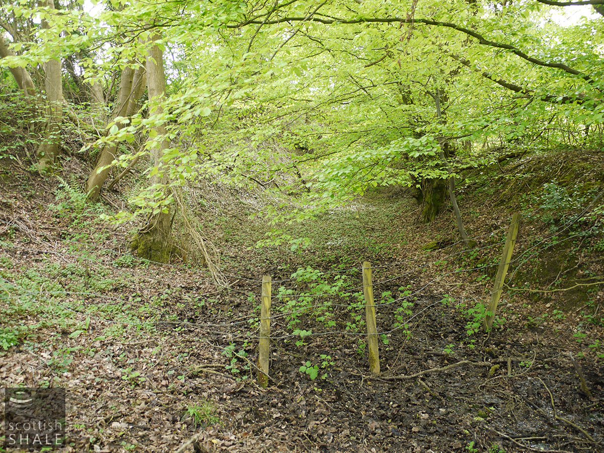
Route of road or haulage linking works site with the mines. Looking south west. June 2014.

Shale exposed on the river bank, close to mine sites. June 2014.
STONEHOUSE. FIRE.
On Sunday night or Monday morning a wooden house, used as a store at the Stonehouse Shale Oil Works, situated at Slayholm, and belonging to Mr M'Naughton. railway contractor, was destroyed by fire. The origin of the fire is unknown but it is supposed to have been caused by some cinders falling from the fire-place on to the floor. There was a considerable quantity workmen's tools in the place, which were also burned. The damage is estimated from £30 to £40.
Hamilton Advertiser, 21st March 1868
.......
Boy Drowned.
On Wednesday boy named Robert Stewart, aged 13 years, son of William Stewart, manager, Oil Works, was drowned while bathing in the Avon. The boy had left the Oil Works, whence he had gone with his father's breakfast, about ten o'clock, had gone into the water (some yards distant) to bathe, got beyond his depth, and, not being able to swim, was drowned. News had arrived at the works about that had not returned home, and a search was immediately instituted, when his body was found in 5 feet of water.
Hamilton Advertiser, 13th August 1870


